Update of the Research Program Salinisation – Kierbesluit Haringvliet
Starting in 2022 Svašek Hydraulics is working in close collaboration with Hydrologic on updating the Salinisation Research Program. This program directly supports the Kierbesluit Haringvliet (decree to open the sluices during flood), carried out by Rijkswaterstaat.
Construction of the Delta Works
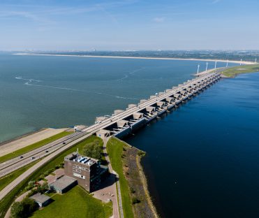
The Haringvliet sluices, constructed as part of the Delta works in 1970, form a hard boundary between salt water of the North Sea and fresh water in the Haringvliet estuary. Before its construction, migratory fish, such as salmon and trout, could swim from salt to fresh water to spawn. Such migration is now very limited. Biodiversity in the Haringvliet and Rhine basin has suffered greatly as a result and many species of plants and animals have disappeared.
Kierbesluit Haringvliet
From 2018 onwards, a testing campaign is underway in which the Haringvliet sluices are regularly opened during flood. The aim of opening the sluices is to promote international fish migration and improve biodiversity, but it also results in the western part of the Haringvliet becoming saltier. The Kierbesluit is a decree that stipulates – among other things – that fresh water intake east of the Middelharnis-Spui line must be guaranteed. The sluices can therefore only be left open during flood if the fresh river discharge is large enough to push back any intruding salt that threatens to go beyond this line.
Learning by doing
In practice, the uncertainties in the Kierbesluit about fish migration and salt dispersion are taken into account with the use of ‘Learning by doing’. A responsible operating protocol for the Haringvliet sluices is being composed by making step-by-step risk-driven decisions. Practical tests, model analyses, data analyses and expert knowledge are used to learn about the behaviour of salt water in the Haringvliet and to optimise the strategy of sluice operation for fish migration.
3D model simulations
Svašek Hydraulics carries out the 3D model analyses within this project, aimed at predicting the salt dispersion in the estuary and effects of measures designed to limit salt intrusion. In intensive collaboration with Deltares, a dedicated D-Flow FM model of the Haringvliet is being improved and applied: a model with 311 vertical layers, which is able to reproduce the fresh-salt water interaction processes in the Haringvliet.
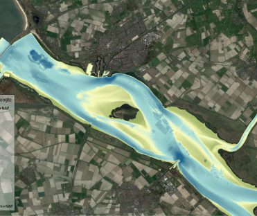
By defining scenarios, Svašek Hydraulics explores various measures and operations that put the Kierbesluit into practice. The unique character of the Haringvliet, with its deep pits, channels and intertidal shoals, results in a complex process of salt dispersion.
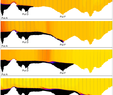
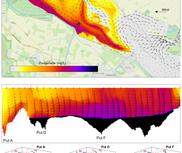
Model simulations have shown that horizontal recirculation in the system as a result of specific wind conditions is a determining factor for the risk of salt transport eastwards towards the Middelharnis-Spui line. This has also been shown previously in analyses of observations1. The inclination of the salt water interface in pits and the overflow of salt water between pits during such wind conditions are key processes. Finally, the way salt water is being stirred up from the pits during storm or unfavourable wind conditions is being investigated with model simulations. Measures to push back the salt towards the sluices or to contain the salt in the pits are examined. The obtained knowledge from model simulations is used to develop the operating protocol for the Haringvliet sluices.
1) Kranenburg, W., Tiessen, M., Blaas, M., and van Veen, N., 2023. Circulation, stratification and salt dispersion in a former estuary after reintroduction of seawater inflow. Estuarine, Coastal and Shelf Science 282. https://doi.org/10.1016/j.ecss.2023.108221.
Want to know more?
Want to know more about the 3D model analyses that Svašek Hydraulics carries out within this project? Contact Sam Bom.
Sam Bom
Lead rivers, estuaria and complex currents

MORE INFORMATION ABOUT SVAŠEK OR OUR EXPERTISES?
Please contact us or make an appointment.
CONTACT US


